Search icon CANCEL
Subscription
0
Cart icon
Your Cart (0 item)
Close icon
You have no products in your basket yet
Save more on your purchases! discount-offer-chevron-icon
Savings automatically calculated. No voucher code required.
Arrow left icon
Explore Products
Best Sellers
New Releases
Books
Videos
Audiobooks
Learning Hub
Free Learning
Arrow right icon
Arrow up icon
GO TO TOP
GeoServer Beginner's Guide

You're reading from   GeoServer Beginner's Guide Share geospatial data using Open Source standards

Arrow left icon
Product type Paperback
Published in Oct 2017
Publisher Packt
ISBN-13 9781788297370
Length 384 pages
Edition 2nd Edition
Arrow right icon
Author (1):
Arrow left icon
Stefano Iacovella Stefano Iacovella
Author Profile Icon Stefano Iacovella
Stefano Iacovella
Arrow right icon
View More author details
Toc

Table of Contents (13) Chapters Close

Preface 1. GIS Fundamentals FREE CHAPTER 2. Getting Started with GeoServer 3. Exploring the Administrative Interface 4. Adding Your Data 5. Accessing Layers 6. Styling Your Layers 7. Creating Simple Maps 8. Performance and Caching 9. Automating Tasks - GeoServer REST Interface 10. Securing GeoServer Before Production 11. Tuning GeoServer in a Production Environment 12. Going Further - Getting Help and Troubleshooting

Representing the world

In the previous sections, we explored spatial data and SRS. They are the key elements you need to build your map. Indeed, maps are a planar representation of spatial data. You need to collect the appropriate data to represent the real objects you want to include in your map, and you need to choose an SRS to organize your data onto the map.

Keep in mind that maps are representations, a proposition of yours. They are the way you express your knowledge and your vision of the world. To fully accomplish this, there is a third basic ingredient for your map: symbology.

Symbology enables you to add information to the features shown on a map. For example, colors can be used to indicate a classification of roads. Imagine you need to produce a map of a country with a road network. You have a vector dataset containing road polylines. A simple approach is to render all features with the same symbol, as shown in the following figure. The map is not really informative unless you are a transportation expert. You won't extract any information from the map and it looks ugly too.

Let's take a look at a similar map produced with ArcGIS Online (http://www.esri.com/software/arcgis/arcgisonline).

It contains the road network symbolized with different colors and line widths, labels showing you highway codes, and major towns represented with small circles and labels. Besides, there is a background depicting heights with colors and shading. Does it now look more familiar to you?
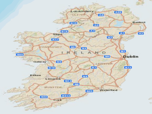
In Chapter 6, Styling Your Layers, you will learn how to apply symbols in GeoServer to produce maps like the previous one. For now, you need to familiarize yourself with simple and thematic maps.

Exploring OpenStreetMap

Are you ready to explore some nice maps? We will navigate through a great bunch of spatial data, OpenStreetMap. Perform the following steps:

  1. Open your browser and go to http://www.openstreetmap.org.
  2. The website offers you a small scale map centered on your actual location, as derived from the browser information:
  1. Center your map on London, UK, and zoom in with the tool shown on the left-hand side. You can see that many more road types and locations are now shown in this map:
  1. Now, enter the Piccadilly Circus, London, UK address in the Search textbox on the left and click on the Go button. A list of results matching your search is presented on the left side of the map. Pick the first item:
  1. The map is now at a great scale (look at the scale bar on the bottom-left of the map panel) and the symbols changed to show you greater detailed information about roads and locations. You can find street names, directions for car traffic, buildings' footprints, and icons for points of interest. The general look and feel resemble a printed city map you can pick up at tourist offices.
OpenStreetMap does not require you to register for browsing or exporting the data. Anyway, if you are interested in maps and open source data, you may consider getting involved in the project. OSM is a collaborative project to create a free editable map of the world, currently involving over half a million users all around the world. You may add data or find errors on locations you know well.

You explored several maps representing the same data set in quite different ways. Different symbols and hiding subsets of data are powerful tools to produce clear and nice looking maps. You are now ready to discover a different kind of map.

You have been reading a chapter from
GeoServer Beginner's Guide - Second Edition
Published in: Oct 2017
Publisher: Packt
ISBN-13: 9781788297370
Register for a free Packt account to unlock a world of extra content!
A free Packt account unlocks extra newsletters, articles, discounted offers, and much more. Start advancing your knowledge today.
Unlock this book and the full library FREE for 7 days
Get unlimited access to 7000+ expert-authored eBooks and videos courses covering every tech area you can think of
Renews at $19.99/month. Cancel anytime
Banner background image